Home > Archive > History of Blair
History of Blair
Platted: May 10, 1869
Township 18 North Range 11 East of the Sixth Principal Meridian
Longitude: 96º14’W Latitude: 41º56’N Elevation: 1000 ft
Blair, county seat and largest city in Washington County, was not one of its earliest towns. It was established when the Sioux City & Pacific Railroad chose to cross the river at that location, going from Missouri Valley, Iowa, and up along “Carter Hollow” on the Nebraska side. Whether by chance or design, the route missed the existing river towns of DeSoto and Cuming City. An entirely new town was needed.
A 1,075-acre tract of land was purchased and platted, with lots to be sold at auction on May 10, 1869. The entire tract was purchased by John I. Blair, an official of the railroad, who announced his plans for the city, which he named for himself.
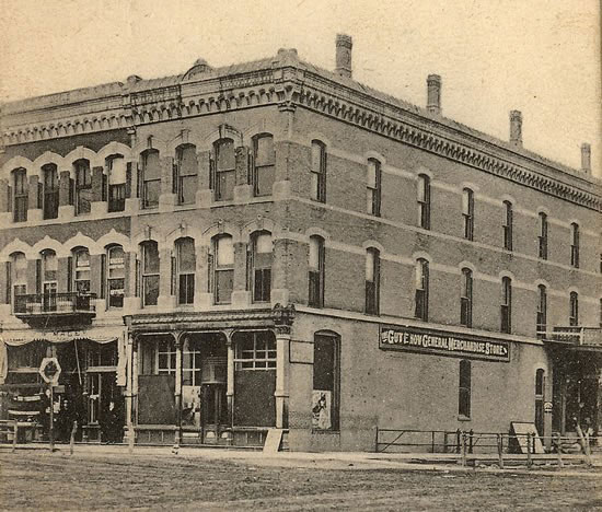
Front street quickly took shape. Many businesses and several churches were hauled overland from the former town sites to supplement those being built. In a short time there were hardware, implement, and dry goods stores, a hotel, a bank, and a newspaper. A town board was formed in August.
Before the end of the year, the town called for an election to relocate the county seat, which at that time was in Fort Calhoun. Blair won, and a brick courthouse was erected at 19th and Grant.
Construction was also progressing on the rail line. Before a railroad bridge was built across the Missouri, freight cars were pushed onto barges on one side of the river, then pulled off on the other. Since the engines did not cross the river, a roundhouse to service them was built north of town. When the bridge was completed in 1882, that facility was dismantled and servicing was done in Iowa.
Local brickyards turned out 1,500,000 bricks per year to meet the demands of the city’s rapid development. In 1884 the community, predominantly Danish, raised $3,000 in matching funds and appropriated several acres of land on which to establish a “folk school.” The forerunner of Dana College, Trinity Seminary was housed in a home until the impressive, four-story main building was dedicated in 1886.
By then a city water system was in place, and South Creek, dug out by men with hand shovels, had been straightened to improve the drainage on south side of town. A public high school was constructed before the turn of the century.
Industries that sprang up along the railroad include: a mill which produced Maintop flour and livestock feeds; a foundry manufacturing roller bearings; a laboratory which made patent medicines; a poultry incubator plant employing about 40 men; and a horse collar company which employed up to 125 men, until “horses left the drawbar scene.”
A plant, built in 1889 to provide electricity for lights, was not dependable or profitable. In 1914 a new municipal power plant was built and later a city ice plant was added to supply Blair with “safe ice,” replacing the system of cutting it from the river.
Over the years, other enterprises came and went: a plant manufacturing spark plugs used in Model T Fords; a canning company; a seed corn plant; and a church-publishing house. Currently, Kelly Ryan Equipment Company, established in the mid-1940s, employs up to 50 persons.
The “Bee-Line” Highway, started in 1923, got little use until a bridge was built across the Missouri at Blair in 1929. Later designated as Highway 30, paving was completed as a Federal Works project in the 1930s. Highways U.S.73 and State 91 and 133 were completed later.
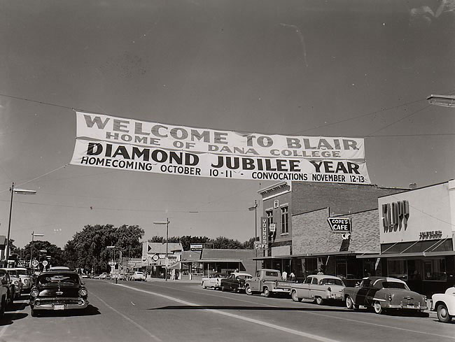
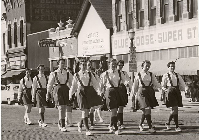
Today, a progressive business district is flanked by a modern shopping center. There is a new middle school complex, a golf course, a municipal airport, and a swimming pool. As many as 100 new homes have been added in a single year. Spacious parks, designed into the existing landscape of the state arboretum system, further enhance the natural beauty of Blair. In 1990 the population was 6,900 and growing.
— from material found in Washington County History
More information on Blair's History
The Missouri River passed through a natural opening in the bluffs, known as Carter Valley , some twenty river miles north of Omaha . To take advantage of this excellent river-level crossing site, the Sioux City and Pacific Railroad routed its line to this point when surveying between Sioux City and the Union Pacific transcontinental route in 1864. Five years later, investor John I. Blair acquired the railroad, purchased 1075 acres of land about 1-1/2 miles west of the crossing and platted a town, naming it after himself. The town of Blair grew quickly – almost overnight – in the tradition of 19th Century speculative towns, and soon assumed a role as regional nexus of overland transportation.
Faced with the prospect of building an expensive and technologically untried structure to span the Missouri permanently, the SC&P skirted the problem in the 1870s by ferrying its trams aboard steamer boats. Each fall, railroad crews erected “winter bridges” – temporary timber trestles supported by driven piles – to carry the trains over the frozen river. The winter tracks broke up each year with the spring ice melt, however, and the transfer steamers had severe liabilities of their own. Time-consuming and dangerous, they were subject to interruption by downriver boat traffic and seasonal freezing and flooding. Moreover, the cumbersome transfer operations created tremendous bottlenecks during peak freighting seasons, snarling rail traffic far hours or days. For pedestrian and vehicular traffic, ferry transportation remained the only mode of crossing the river at Blair; passage came to a complete halt during the winter.
Late in 1881, the SC&P contracted with civil engineer George Morison to design a permanent bridge over the river at Blair. The relatively flat nature of the riverbanks that had benefited the ferry operation did little to help with the construction of a bridge. In this, the Blair site differed topographically from those of virtually all other previous Missouri River bridges. According to Morison, the best location far a bridge over the Missouri was just below one of the great bends, especially if the current impinged on a rocky shore. Under such conditions, the bedrock beneath the river was generally shallow on the bluff side, where the main channel flowed. The least promising location was on a long, straight stretch, where the bedrock was usually found at great depth and the current veins were likely to be variable. This would make it necessary to sink excessively deep foundations, construct extensive shore protection to control the channel and erect an unnecessarily long bridge.
Blair was founded in 1869. It is favorably situated on a plateau about eighty feet above and two and a half miles from the Missouri River, and in north latitude forty-one degrees and thirty-two minutes. The original settlers upon this beautiful plateau were three brothers – Jacob, Alexander and T. M. Carter, who had located here in May, 1855.
In 1864 the Northern Nebraska Air-Line Railroad Company was organized, and in 1867 received a grant of seventy-five sections of land, which grant was transferred to the Sioux City & Pacific Railroad Company, during the same year, the company being composed of John S. Bowen and four other gentlemen. In 1868 John I. Blair and associates became owners of the franchises of the road. In June, the people of Washington County, at a special election, voted to the S. C. & P. Company, $75,000 in county bonds, and the company which had been awaiting the result of the election, immediately thereafter, under the management of John I. Blair, pushed the road across the Missouri, and built it centrally through the county, from east to west, to Fremont, reaching there before December 1, 1868. During construction of this road, speculation was rife as to the exact location of the prospective railroad town. De Soto’s hopes of being the eastern terminus of the road had been cruelly nipped in the bud by the decision of the company to cross the Missouri River three miles above where she was located, the place of this crossing of the river being determined by the existence of Carter Valley, which here runs down to the Missouri, affording a natural opening through the bluffs. Then the question of the location of the town was settled, upon the purchase by the railroad company of the three Carter brothers, named above as original settlers, and of James S. Stewart, William Temple and C. H. Beekman, of 1,075 acres of land; this land being the present site of Blair, and the offering of this land for sale, in lots at public auction. This sale took place on the 10th of March, 1869, and lots to the aggregate value of $61,000 were sold that day, the highest price paid for any one lot being $350.
This sale was conducted ostensibly by the Railroad Company, but in reality John I. Blair purchased the whole tract of the original settlers; it was he who sold the lots, and it was he in whose honor the town was named. From this time the future of the town of Blair seemed assured, and ever since she has experienced a healthy growth. Business men and many people from other less favored towns in the county, as well as strangers from outside the State, hastened to Blair. In 1869 the county seat was removed here from Fort Calhoun.
Adjust the text size


Featured Pictures
Archive Links
BHPA Links
Blair Historic Preservation Alliance | P.O. Box 94 | Blair, Nebraska 68008 | contact@blairhistory.com